or, on the right side of it to go to the next page.
If you mouseover
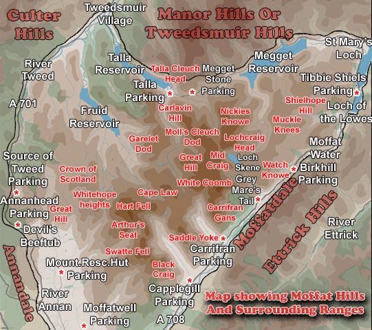
the above image you can see walking routes we have used in these hills.
The routes with a black outline are all numbered because they are covered
on this site. Clicking on the following numbers will take you to the relevant
walk - 1 - 2
- 3 - 4
- 5 - 6
- 6a - 7.
The two routes in pink with a white outline are routes we have done but
they are not shown on the site. There are 3 hills
over 800 metres in these hills - White Comb (821m), Hartfell (808m)
and Lochcraig Head (801m). The town of Moffat lies just off the map south
of Moffatwell and along with Tweedsmuir is the only centre of population
around the Moffat Hills.
This range forms a distinctly triangular shape with a west facing side,
a north facing side, and a south east facing side. It is 17 kilometres
from east to west across this triangle and some 16 Kilometres north to
south
The west facing side is bounded by the Rivers Annan
and Tweed
- the source of both these rivers (which are little more than 1 kilometer
apart) lie on this boundary. The Annan
runs south into the Solway Firth but the Tweed
heads north and then east to run through the
border country to the North Sea at Berwick
on Tweed. The A701 road from Moffat
to Edinburgh follows the valleys of these rivers and passes the Devil's
Beef Tub at the source of the River Annan in the administrative region
called Dumfries
and Galloway. The source of the Tweed is in Borders
Region. The regional boundary runs erratically eastward from near
there, then goes north around Loch
Skene before heading south east to Birkhill
Cottage where it goes up onto the Bodesbeck
Ridge in the Ettrick Hills and heads south west all the way down to
Capel Fell before looping
north eastward again - so it loops round the head waters of the River
Ettrick- which are in Borders Region.
The north facing side is bounded by an unmarked road (no road number on
the OS map) which runs from Tweedsmuir
village to St
Mary's Loch (passing along the banks of the Talla
and Megget Reservoirs
and rising to 450 metres by the Megget
Stone). The hills to the north here are called the Manor
or Tweedsmuir hills and the hills to the north west of the Moffat Hills
are called the Culters
(pronounced Cooters).
The south east facing side of the Moffat hills runs south west down the
shore of St Mary's Loch
and Loch of the Lowes and then follows the Moffat Water down Moffatdale
past the Grey Mare's Tail
waterfall. The A708 Moffat to Selkirk
road runs along this route twisting and turning through some spectacular
scenery with strongminded sheep (who don't like moving for you) wandering
the unfenced road.
As a hill walker you can come at these hills from any side you choose.
The parking places marked on the map are ones that we have used many times.
The Moffat Hills particularly around Loch
Skene offer outstanding classic geological features. Loch Skene has
also been used succesfully
to try to preserve the endangered species of fish called the Vendace
which it seems has a history going back to geological times -
Colin Bean, Scottish Natural Heritage's freshwater
adviser says: "Vendace are one of the few fish that managed to colonise
Britain at the end of the last ice age nearly 13, 000 years ago and as
such, are an important link to our glacial history. The fact that we have
managed to save this valuable part of our native biodiversity from extinction
by moving a small number of these fish to Loch Skeen in Scotland is an
excellent example of how government can work together with a range of
other organisations to achieve a practical conservation result."
See Loch Skene in winter
conditions and you can see why the vendace is at home here.