The map shown on the right shows the various hill walking
areas at the western end of the border hills covered in this site.
- the Culters
("Cooters"),
- the Tweedsmuirs
or Manor Hills
- the Ettrick
Hills
- the Moffat
Hills.
The map covers an area of 26 kilometers from east to west and 29.4 from
north to south. The eastern edge of the map is in fact in a line due south
from Edinburgh. Compared with the Galloway hills it is worth noticing
how much of this map is over 300m (or 1000ft, roughly). Here we do not
have distinct high ridge systems separated by deep valleys as in Galloway,
but something more like a general moderately high plateau area broken
into by the water systems. The water systems are noteworthy here too -
with historic names such as Tweed,
Annan,
Ettrick and even the Clyde
showing right up in the north west corner of the map.
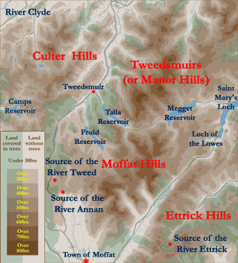
The Annan arises at Annanhead immediately above the
Devil's
Beef Tub and flows south past the town of Moffat and on into the Solway.
The source of the Tweed is less than 2 kilometers (a mile) away. It runs
NE past Tweedsmuir and ends up on the Scottish/English border at Berwick-on-Tweed.
The Ettrick joins it on it's path to the sea.
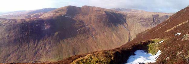
Another obvious water system on the above map is the humble Moffat Water,
running SW from the watershed near Birkhill
just SW of Loch
of the Lowes to join the Annan below Moffat. Moffatdale, as this valley
is called, is not only particularly beautiful but is also an outstanding
example of the effects of glaciation with classic hanging valleys on the
north side of it.
The final water system to note is the route through from Tweedsmuir to St Mary's Loch via the Talla and Megget reservoirs. This is a spectacular journey by car and offers a parking place at 452m from which to access the hills for those who like a flying start onto Broad Law which is the second highest hill in the south of Scotland - just 3 meters lower than Merrick - but miles lower than it in spectacle - being a big boring whale back with an air traffic control station on top. Go on to Dollar Law past Cramalt from there and collect 3 hills over 800m in one relatively easy day. And if it is clear enough on Dollar Law you will be able to see Edinburgh Castle, Arthur's Seat, the Firth of Forth and the kingdom of Fife beyond it.