|
|
|
|
|
|
|
|
|
|
|
|
|
Hill walk routes to climb in SW Scotland
- also coastal paths and National Scenic Areas with maps, pictures and
other useful information based on extensive local knowledge
|
|
|
|
Grey Mare's Tail and
Loch Skene Routes (1)
|
|
|
|
|
|
|
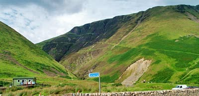
| The
area covered by these walks is in National Trust property - the Grey Mare's
Tale is a very popular tourist attraction. There is a warden's hut by the
car park which acts as a visitor centre and there is a well built footpath
up towards Loch Skene on the north side of the Tale Burn. This path is well
used by casual visitors in casual footware who have been known to ignore
the warnings of danger if you leave the path - there have been one or two
fatalities here in recent years. So be warned. In wet or icy conditions
you would be off sliding down into the Tale Burn from quite a height if
you don't stick to the path. The picture is taken from the road.
There is also a web gallery of a winter
walk around Loch Skene dating from 10th December 2008 which you might
like to compare with the information given in these three pages. |
|
|
|
You can see cars parked beyond the wall, the warden's
hut. and the light line running up the side of the hill is the track up
to Loch Skene. The direct route from the car park to White Coomb, shown
in yellow on the map, goes straight up the hill behind the hut. It
is over steep grass and is not recommended for wet or icy conditions.
|
|
|
|
|
|
|
|
|
|
|
 |
|
 |
|
|
|
|
|
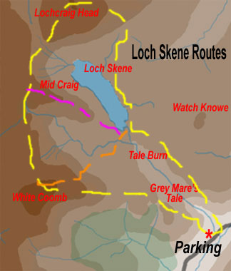
For many casual visitors, up the path to Loch Skene
and back down is a considerable achievement. When you get above the waterfalls
on that route you can cross the Tail Burn, if the water is not too high,
and head west for White Coomb (Green route). You can go on up to the point
where the Tail Burn runs out of Loch Skene, cross the burn and head SW
for White Coomb (orange) or head NW for Mid Craig and from there make
for either White Coomb of Lochcraig Head (purple). The top of White Coomb
does not have the spectacular view you get from Lochcraig Head though.
Heading north up the east side of Loch Skene for Lochcraig Head takes
you through some very boggy ground. Don't follow the water's edge - follow
the path along the fence and it will be a bit drier.
|
|
|
|
|
 |
|
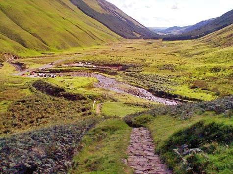
| The picture on
the right shows a view from the path up to Loch Skene, looking back down
Moffat Dale with the Tail Burn running down past the car parks. The road
which runs up through the valley is the A 708 from Moffat to Selkirk - a
very picturesque route, though the road is narrow and twisty. You can see
in this picture how much effort National Trust for Scotland |
|
|
| has
put into building a good path - right up past the waterfall. They say that
they brought the stones in for it by helicopter. It was certainly a major
undertaking. |
|
|
 |
|
 |
|
|
|
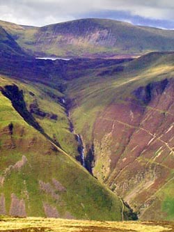
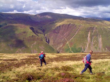
These
2 shots are taken from the Bodesbeck
Ridge, looking over Moffat Dale at Grey Mare's Tail, Loch Skene and
Lochcraig Head. |
| The
path up to Loch Skene is quite visible in both pictures. The shoulder in
the left foreground of the picture on the left is the direct route up from
the car park to White Coomb - a bit dodgy in slippy conditions unless you
really know what you are doing. |
|
|
|
|
|
|
 |
|
|
|
|
|
|
|
|
|
|
|