or, on the right side of it to go to the next page.
01 This web gallery is very much a sister to the Broad
Law web gallery. That is why I have included so much of the Manor
Hills in the map above - so that you can relate the two walks one to the
other (the south end of the Manor hills lies north of the Megget Stane
and the north end of the Moffat Hills lies south of it in the above map).
There is also a web gallery of a winter walk from the Grey Mare's Tail
around Loch Skene
taking in Lochcraig Head which carries this sequence of walks further
south into the Moffat Hills.
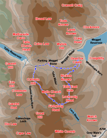
On the map it says Megget Stone but I really can't bring myself to call
it that. We call it "Stane" rather than "Stone" and
you lose much of the flavour and authenticity of the place by anglicizing
the word. So just bear with my aesthetic scruples over this. Likewise,
Dead for Cold just wouldn't carry the cultural significance of the name
Dead for Cauld that this hill actually has on the map
This is not a very long walk. I took 5 hours to it but on several occasions
I had to wait for the squalls of rain to pass over to get the shots. It
was a day when these rain squalls came charging in on a strong westerly
wind while bright sunshine penetrated the gaps in the cloud to cover the
landscape in sharp lights and darks - not easy to photograph! It was also
quite a cold day on the tops.
You could probably do this route in around 4 hours. It is easy going all
the way with nothing much in the way of steep or long ascents. With views
to be got over the Megget Reservoir, Loch Skene and then the Talla Reservoir,
it is really quite an interesting walk scenically and if you are interested
in bagging hills over
800 metres Lochcraig Head will add another to your list.
If you wanted to make a longer day of it you could either go onto White
Coomb, bag another 800 metre hill there, then make your way back to Firthybrig
Head and get back onto the above route from there
or
Go down over Great Hill and up onto the Garelet Dod/Erie Hill Ridge with
a steep descent off Garelet hill above the Talla Reservoir - which is
quite interesting to do. But then you would have to walk back up the road
to the Megget Stane from the reservoir at the end of the day - which is
no big hassle.