Hill walk routes to climb in SW Scotland - also coastal paths and National Scenic Areas with maps, pictures and other useful information based on extensive local knowledge
Carrifran, White Coomb and Saddle Yoke 1

Go to Carrifran 2 - Main Borders Map - Site Homepage
Borders Homepage - Borders Web Gallery List - Moffat Hills Introduction

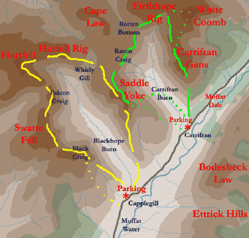
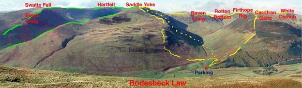
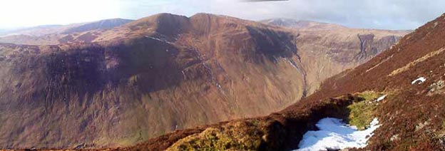
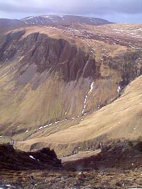
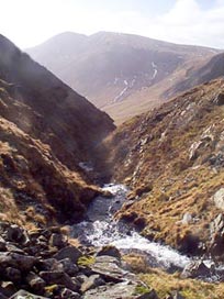
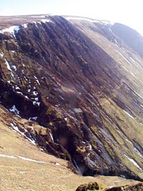
We are looking here at two of the best walks in the South of Scotland. The Yellow walk will be discussed on it's own pages but it is useful to have it here so that you can see the relationship between the walks. You will see that for both walks there are a couple of alternative routes lightly suggested on the map by a more broken yellow or green line. The more solid lines in both cases are the routes we normally take. The first time you go up you will probably want to have a look at White Coomb. We don't find it all that special; with it's big flat top you don't see that much from it. Which route we choose coming off Saddle Yoke for Carrifran depends on the weather conditions.

Map of walking routes over Carrifran, Saddle Yoke and Hartfell
Mouseover on the picture below to see it without routes and the names of the hills.
View of the Moffat hills from Bodesbeck Ridge
If instead of going up to White Coomb, you stay with the front edge of the cliffs between Carrifran Gans and Rotten Bottom, and descend to the head of the water falls cascading off the hill, you will always be with the spectacular views down into Carrifran Glen and over to Saddle Yoke and Hartfell beyond it. The Crags around here are very impressive too as are the series of waterfalls. The descent east off the saddle of Saddle Yoke straight down into the Glen is very steep and a bit dodgy in wet or icy weather, but again you get some super views up the Glen and then the walk down through the Glen promises to be quite interesting as the experimental plantation there evolves.
Where to park near the cattle grid at Carrifran View from Carrifran back over the route we have come up
There is a farm called Carrifrans on the Moffat to Selkirk road (A708). Just east of it there is a cattle grid and a gate beside it for non existent horse drawn vehicles to use. That's where we park. There is a gate just out of the picture to the left and from there you make your way across boggy ground towards another gate over by the trees and then up the obvious fence line. The picture on the right above gives a fair impression of the steepness.
View of Saddle Yoke from Carrifran Gans
This (above) is the view of Saddle Yoke as you approach the top of Carrifran Gans. Hartfell can be seen to the right of Saddle Yoke, and the dark face to the left of it is Black Craig.
Looking across to Raven Craig from above the waterfalls between Carrifran and Rotten Bottom Looking across to Saddle Yoke from the waterfalls between Carrifran and Rotten Bottom Looking back to Carrifran Gans while traversing the face of Firthope Rig
Looking across to Raven Craig from above the waterfalls between Carrifran and Rotten Bottom. Hartfell is in the background. In among the waterfalls looking over to Saddle Yoke. Looking back to Carrifran Gans while traversing the face of Firthope Rig. You can see the waterfalls in the foreground.
Go to Carrifran 2 - Carrifran - Saddle Yoke - Swatte Fell - Loch Skene - Beef Tub - Loch Fell Hartfell Spa - Main Borders Map - Site Homepage - Moffat Hills Introduction