Capel
Fell, Loch Fell and Croft Head Round
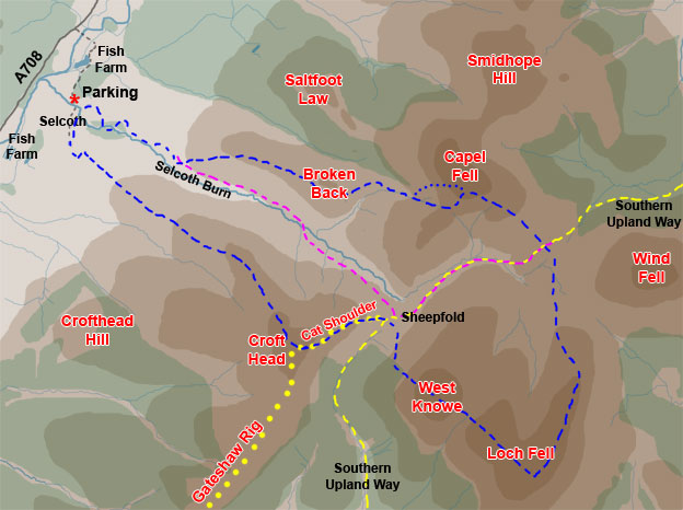
Map
of a circular hill walk from Selcoth in Moffatdale over Capel Fell, Loch
Fell and Crofthead in the Ettrick Hills
Click on
the left side of the image to go back to the previous image and on the
right side of the images to go to the next image.
01 The pictures
shown in this web gallery are of the blue route. The yellow route is part
of the route of the Southern
Upland Way which crosses 212 miles of southern Scotland from coast.
You will see that there is a dotted section and a dashed section of the
SUW shown on this map. The dotted section was due to open in the spring
of 2007 and is a new high level alternative to the section which runs
through woodland.
The purple route offers a much shorter less demanding route allowing you to go up the Selcoth Burn to the sheepfold and back by either Capel Fell or Crofthead without going to Loch Fell at all. We have in the past also gone up onto Capel Fell, down the SUW to the sheepfold and then back over Crofthead. So there are a few options.
The pictures were taken on 21st March 2007 and I took 5 hours to the blue route. I took 133 pictures and I went out of my way to get the particular angles I wanted which all takes time. In particular you can see a dotted section on the blue route which I took for camera angles even though it meant a much steeper climb.