|
|
|
|
|
|
|
|
|
Hill walk routes to climb in SW Scotland
- also coastal paths and National Scenic Areas with maps, pictures and
other useful information based on extensive local knowledge
|
|
Galloway
and Minnigaff Hills - Introduction |
|
|
|
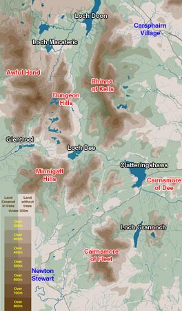
The
map below gives some idea of the general layout of the Galloway Hills, their
heights, and the ranges which make up this large wilderness area. Click
here for a larger map |
|
The Awful
Hand runs north/south from Shalloch on Minnoch over
Tarfessock, Kirriereoch, Merrick and Benyellary to Glentrool (thus making
up the 5 westward-running fingers of the hand). Merrick at 843m is the
highest hill in the south of Scotland.
The Rhinns
of Kells also run N/S from alongside Loch Doon to near
Loch Dee and has 2 tops over 800m, Corserine and Carlin's Cairn, and 3
tops over 700m, Meikle Millyea, Milldown and Millfire.
The Dungeon
Hills lie between these 2 ranges, are not so high but
much more rugged with some excellent rock climbing on the likes of Dungeon
Hill, Craignaw and Craiglee.
The Minnigaff
Hills lie south of Loch Trool and run eastwards beyond
Loch Dee from Muldonnoch, over Lamachan and Curleywee to Cairnbaber and
Darnaw just west of Clatteringshaws. They present some excellent views
into the other ranges.
Cairnsmore
of Fleet (711m), is the highest hill in a range of it's
own much nearer the Solway Firth.
Cairnsmore
of Dee (493m) also lies in it's own
even smaller range but it has nevertheless an interestingly rugged approach
from the south and excellent views northwards from the top.
|
|
|
|
|
|
|
|
|
 |
|
|
Part of the third "Cairnsmore"
in this area (Cairnsmore
of Carsphairn)
(797m) can be seen at the extreme north east corner of the map,
but this hill lies in the Scaur
section of our site. |
| The
area covered by the map is nearly 21k west to east and 35.6 north to south.
Notice that the only towns/villages are Newton
Stewart and Carsphairn
both on the periphery of the area, and that public roads are few and far
between - to Glentrool - from Newton Stewart to Clatteringshaws
- and the one which passes through Carsphairn village, are the main access
roads. Notice also how much forest there is in this area. Most of the parking
points marked on the larger map are at the end of narrow forest roads. The
most common access point to the Awful Hand, the Dungeon Hills, and the Minnigaff
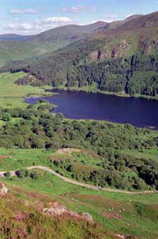
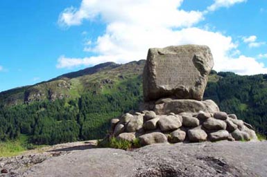
Hills is from the car park near Bruce's Stone at the east end of Loch Trool.
This stone commemorates Robert the Bruces' first victory (1307) in the wars
of independence - which culminated at Bannockburn in 1314. The "battle"
fought here was in fact more of a guerilla type ambush where stones were
rolled down the hill on soldiers trapped between cliffs and the loch. See
the pictures below. Mouseover
the pictures for more information. |
|
|
 |
|
|
For
good websites on rock climbing in Galloway try:
www.needlesports.com/galloway/gallowayindex.htm
or
www.johnbiggar.com/galloway-climbing-index.asp
see also
Galloway
Mountain Rescue website |
|
There
is a walking
festival held in this area each year and the site connected with this
festival offers an interesting introduction
to these hills and the part they have played in Scottish
history. |
|
|
 |
|
|
|
|
|
|
|