|
Hill walk routes to climb in SW Scotland
- also coastal paths and National Scenic Areas with maps, pictures and
other useful information based on extensive local knowledge
|
| Cairnsmore
of Carsphairn and the Scaur Hills |
|
|
| The
Scaur hills lie between the valleys of Nithsdale and the Glenkens. You can
see from the map below that there is not a road running through this group
of hills. From the east, it is possible to get up to Polskeoch by car along
a single track road going nowhere except into the forest. Or, coming in
from the west, you can head up the Water of Ken on a marginally wider road
till it runs out at Lorg farmhouse. You will find both roads equally sparsely
populated and you will be delighted to realise you are entering a secret
hidden little world where few people go. I guarantee you will be surprised
at the beauty and calm peace of the area, and the lively shapes and arrangement
of the hills - especially around Glenwhargen. |
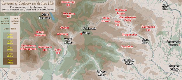 |
The
bigger hills lie to the Carsphairn/Glenkens side with Cairnsmore
of Carsphairn falling just short of 800mts at 797mts. Beninner is 710mts,
Windy Standard
698mts and Moorbrock 650mts. Blackcraig at the northern end of these hills
(north of the Afton Reservoir) is 700mts and nearby Blacklorg is 681mts.
Around Moorbrock, Windy Standard and Cairnsmore you can build quite a challenging
circular day's walk - as also through to Blackcraig from Water of Ken.
Cairnkinna is the highest on the Scaur Water side at a modest 552m.
These eastern Scaur hills give you shorter, less demanding, yet interesting
sharp little ascents. |
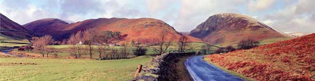 |
| The
picture above shows the Glenwhargen area at road level. Glenwhargen
Craig 482mts is on the right (vertically above the bend on the road),
and the shapely ridge running back through to the snow covered top (Peat
Hill), is Peat Craig. You can see Scaur Water near the left edge of the
picture. |
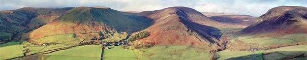 |
| The
picture above shows much the same view but from the top of the hill (Hallscaur
Craig). Glenwhargen Craig is on the right with the Scaur valley (and the
single track road) running between it and Peat Craig - through to Polsheoch.
Dalzean Snout is the next ridge to the left, and the fourth ridge (on the
extreme left) comes along from Chanlock Rig and Craigdasher to Craigbuie
Hill which has mist on the top in this picture. You can see that for all
their modest height they make a visually pleasing group which we could,
for the fun of it, call the "Scaur Alps" They offer plenty of
opportunities for easy yet interesting ridge walks. |
|
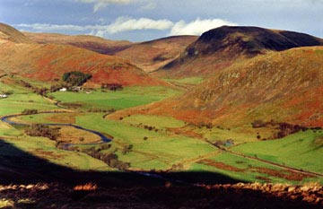
The picture on the right shows the view of the "Glenwhargen
Alps" from Chanlock Rig. Hallscaur Craig (where the previous picture
was taken from) is in the right foreground.
The meanders of Scaur Water can be seen in the left
foreground. This really is a very special part of the world even if it
is on a miniature scale by comparison with the other ranges discussed
in this site.
|
|
 |
|
|
 |
|
|