Source of the River Clyde
Click on the left side of the image below to go back to the previous page
or, on the right side of it to go to the next page.
View of the meeting of Daer Water with Potrail Water - the source of the River Clyde View of the meeting of Daer Water with Potrail Water - the source of the River Clyde View of the meeting of Daer Water with Potrail Water - the source of the River Clyde

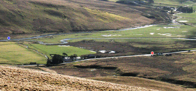
01 As discussed elsewhere on the Queensberry, Durisdeer and Steygail and Enterkin Pass web galleries the actual place where the River Clyde first takes it's name and becomes "the Clyde" is a bit of an enigma. In Glasgow for example it was commonly held that the source of the River Clyde was Tinto Hill. There is also a more realistic saying that the Rivers Tweed, Annan and Clyde all rise from the same hill and there is a Clyde Law (OS Ref. NT027171) which is certainly near the sources of the Tweed and Annan Rivers though there is a short descent and ascent in between. Clydes Burn runs west off Clyde Law, runs past a place called Little Clyde and joins the conjoined waters of Daer and Potrail just south of Elvanfoot (OS Ref. NS963155). But I think the odds have got to be very firmly on the place you are looking at in these pictures (OS Ref NS 954137).
Near the left side of the picture above you can see a blue asterisk at the meeting point of the Daer Water (coming from the top right corner of the picture) and the Potrail Water (coming in from the right side of the picture). There is a third "water" running down to meet the other two at their junction, and this is the Glenochar Burn which you see entering the picture from the bottom right corner and passing under the A702 road - which is the other thin band of light running across the picture from right to left and nearer to us. Glenochar farmhouse, among the trees, is at the roadside where the Glenochar Burn runs under it. The red asterisk shows where there is a visitor's car park for visiting Glenchochar Bastle and Fermtoun which of course you could also use to visit the source of the Clyde. To get from there down to the meeting of the waters you walk east along the road past Glenochar farmhouse, over the Glenochar Burn, and in at the gate just beyond it on your right. Check out the map in the Dun Law web gallery for a larger view of the area than is given in the maps below.
So just by the left edge of this picture is where the River Clyde is born though as you can see in the Ordnance Survey maps below there always seems to be an element of doubt - even Ordnance Survey seemed to go along with the idea of Clyde Law being the source as you can see below and for most people the Ordnance Survey is the ultimate arbiter on such matters.

Going by this detail (shown on the right) from Ordnance Survey Landranger map (sheet 78 scale 1:50,000) you would have placed the Glenochar Burn further downstream than the meeting of the Daer and Potrail Waters. You can see too, that the conjoined waters carry on north as Daer Water. The first time they use the name River Clyde on their Landranger is at the very bottom of the next sheet northward (No. 72) just 7km (less than 5 miles) north of this point where we are here, as the crow flies.
Detail of Glenochar area from Ordnance Survey Landranger map
Detail of the Glenochar area from the Ordnance Survey Explorer map
However on their recent 1:25,000 Explorer map (sheet 329), shown here on the left, the Daer Water name is not used downstream of this meeting of the waters and also, within 1km they call the valley Clydesdale - the valley of the Clyde (the grid squares shown on OS maps are kilometre squares on the ground).
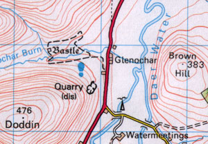
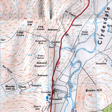
So it would look likely that Ordnance Survey have come round to the notion of the meeting of the Potrail and Daer Waters as being the starting point of the River Clyde as such and with all the various burns and waters further upstream being collectively the head waters.
Map of area - Lowther Home - Lowther List - Site Homepage
Return to Queensberry 19 - Return to Durisdeer 26
Go to page 03         Go to page 02