|
|
|
|
|
|
|
|
|
|
|
|
|
|
Hill walk routes to climb in SW Scotland
- also coastal paths and National Scenic Areas with maps, pictures and
other useful information based on extensive local knowledge
|
|
|
|
|
Durisdeer and Lowther Hills - Introduction
|
|
|
|
|
|
|
|
|
|
|
|
|
|
 |
|
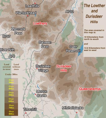
| This
group of hills lies between the valleys of the River Nith and the River
Annan, or if you prefer to think in terms of trunk roads, between the A76
and the M74 corridors which run north/south through the South of Scotland
on it's west side. The whole group of hills is known collectively as the
Lowthers,
though for our purposes it is handy to recognise the section lying south
of the Dalveen Pass (or if you prefer the A702 trunk road) as the Durisdeer
Hills and the hills north of the Pass as the Lowthers.The old lead
mining village of Wanlockhead
at the head of the Mennock Pass is at around 450m the highest village in
Britain. Leadhills
was the birthplace of the famous 18th century poet Allan
Ramsay. His son, also called Allan
Ramsay, was the outstanding British portrait painter of the 1750/60s. |
|
|
|
|
Click
here for a larger map |
|
|
|
|
You
will see from the map that these hills consist of a series of ridges running
SW/NE, the highest ridge being north of the Dalveen, Green
Lowther getting up to 732mts and Lowther
Hill at 725mts.
Among the Durisdeer Hills,
Queensberry is
the highest at 697mts Ballencleuch Law is 691mts and Rodger Law 688mts.
The coast to coast Southern
Upland Way passes up through Wanlockhead and over Lowther Hill. |
|
|
|
 |
|
 |
|
|
|
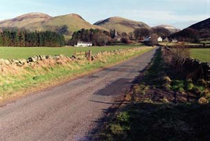
| The
picture above left shows Durisdeer
village nestling beneath the hills. You would park in the village for
some of the walks we will go on to look at. Although the Durisdeer Hills
are not particularly high they are quite shapely, and they offer plenty
of opportunity for fairly easy walking with excellent views. Sandy is looking
at Glenleith Hill from East Morton Hill. |
|
|
|
 |
|
 |
|
|
|
|
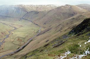
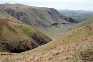
Above left is a view looking NNE down into the Dalveen
Pass from the shoulder of Black Hill, with the pap of Capel Hill on the
right and Caplaw Rig swinging round in a NW direction beyond it (on the
left). In the above right picture we are on Caplaw Rig looking back SSW
down the Dalveen Pass to where the previous picture was taken from.
|
|
|
 |
|
|
|
|
|
|
|
|
|
|
|
|
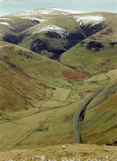
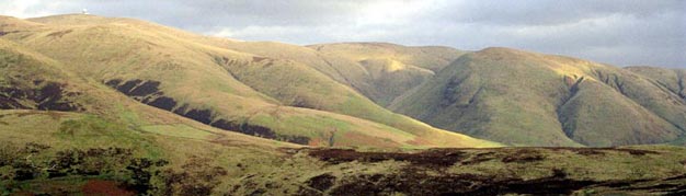
In the picture on the left we are looking over the Dalveen Pass towards
the Lowthers, with the "golf ball" of the aircraft tracking station
on the top of Lowther Hill. The shoulder coming into the picture from the
left is of Steygail which is a particularly shapely hill (see below). The
hill on the right, shaped like a horse shoe (or perhaps more like a traditional
Scottish black pudding, or French Croissant), is Comb Head with Cold Moss
above it before Lowther Hill.
The "Southern
Upland Way"mentioned above is a long distance walk from Portpatrick
on Scotland's west coast to Cockburnspath on the east coast. It comes down
from Lowther Hill over Cold Moss and Comb Head before heading over by the
Daer Reservoir and the upper waters of the River
Clyde.
|
|
|
|
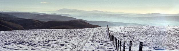
| In
the picture below we are now on the top of Lowther Hill looking south over
the Durisdeer Hills towards Criffel
and the Solway. If you look close enough you can see the Solway both beyond
Criffel and three quarters way across the picture on the right. The hint
of land visible beyond the Solway is the Lake District. The camera with
it's limited tonal range can never pick up the detail as well as you can
see with the naked eye. |
|
|
|
 |
|
|
|
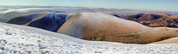
| In
the picture below we are again on top of Lowther Hill but looking SW this
time, over East Mount Lowther towards Cairnsmore of Fleet and the Galloway
hills in the distance. The fire that you see is the burning of heather on
Coshogle Rig. |
|
|
|
|
 |
| The
following picture shows the view back to Lowther Hill from Coshogle Rig.
Notice the "golf ball" on Lowther hill on the left and the mammoth-like
Steygail on the right. The line of the Southern Upland Way runs along the
skyline beyond Steygail. |
|
|
|
 |
|
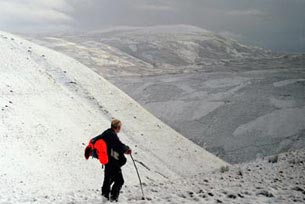
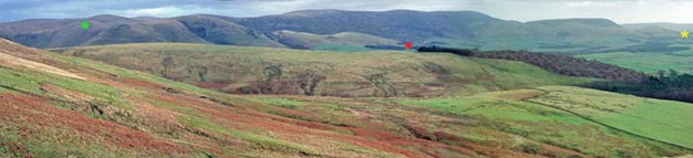
The
picture below shows the whole line of the Durisdeer Hills as seen from the
west - from Coshogle Rig. The green star is placed on Capel Hill, the red
star shows the location of Durisdeer village, and the yellow star shows
the location of Morton
Castle. There is a fine easy ridge walk from Morton Castle by East Morton
Hill and Nether Hill above Kettleton Reservoir. The picture of Sandy in
the the snow near the top of the page was taken on this ridge.
The ridge walk from Durisdeer over by Black Hill towards Capel Hill (from
which three of the above shots were taken), is more obvious in the above
picture. It is quite easy to build several different circuitous walks (long
or short according to your fancy) around these ridges. Here is a link to
a website dealing with walks in the area around Thornhill. |
|
|
|
 |
|
|
|
|
|
|
 |
|
|
|
|
|
|
|
|
|
|
|
|