or, on the right side of it to go to the next page.
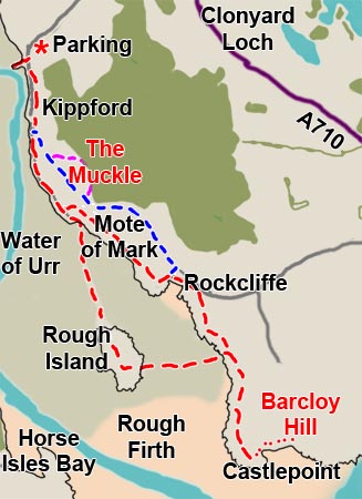
01 There is not much more
than a kilometre from the south end of the coastal village of Kippford
to the north end of Rockcliffe,
but to get from one to the other by car you have to drive inland to the
A710 coast road which bypasses both of them. Between the two of them lies
the 7th century vitrified fort of Mote
of Mark. There is also some very pleasant open woodland between
the two villages with two main tracks running between them - the Jubilee
Path (which you can see in blue in the map above) and the shore path (which
is shown in red between the two villages as part of the overall route
taken in this web gallery). There are all kinds of smaller trails through
the woods which connect both paths and there is also a path from the Jubilee
Path which goes up over The Muckle (100 metres high) and which is shown
in purple in the map above. This route also has it own variants for you
to choose from.
Both Kippford and Rockcliffe are popular holiday villages and these paths
between the two villages are very popular with locals and visitors alike;
they are not at all demanding and, when the weather is fine, require no
more than casual footwear. This area is under the control of the National
Trust for Scotland.
There is a causeway to Rough
Island from the south end of Kippford which of course you can only
use around low tide. You should not go onto Rough Island during the breeding
season - in the months of May and June. To go out to the island you will
require wellington boots