There are three major valleys which break through
the hill ranges of South West Scotland creating the main corridors which
mankind has travelled down through the ages. In the east is Annandale,
which runs between the Queensberrys/Lowthers and the Moffat/Ettrick hills
and which becomes the Valley of the River Clyde (hence "Clydesdale"
in Lanarkshire) once you pass over the watershed near Abbington.
The next valley to the west of this is that of the River Nith (hence Nithsdale)
coming south to Dumfries from Thornhill, Sanquhar and the high moorland
area which separates Dumfriesshire from Ayrshire - from which moor the
River Afton (hence Glenafton) flows north west. The Nith separates the
Queensberrys/Lowthers from the Scaur Hills. Criffel and Screel are quite
modest isolated hills by the coast, but they are justifiably popular with
the local population for the excellent views to be got from them across
the Solway to the Lake District.
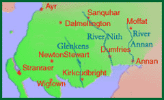
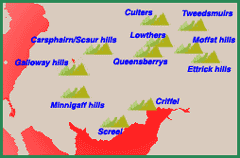
For convenience, hills east of the River Annan are called the Borders in this site:
- those west of the Annan and east of the Nith are called the Lowther hills
- those west of the Nith and east of the Glenkens are called the Scaur hills
- west of the Glenkens we have the Galloway hills.