Rhinns of Kells from
Fore Bush - Corserine, Millfire, Milldown and Meikle Millyea
A circular hill walking
route from Fore Bush onto the Rhinns of Kells in the Galloway Hills taking
in Corserine, Millfire, Milldown and Meikle Millyea
Click on the left side of
the image to go back to the previous image and on the right side of the
images to go to the next image
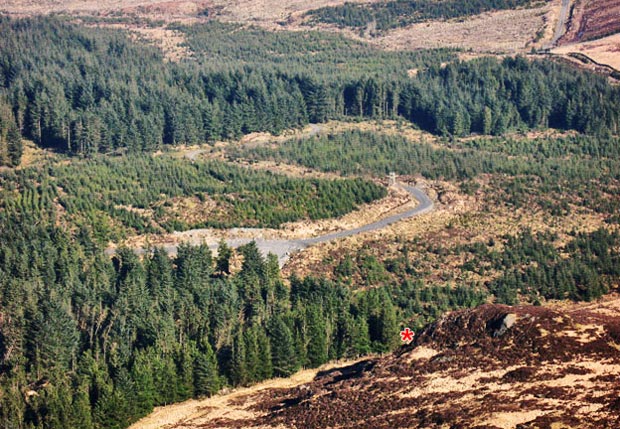
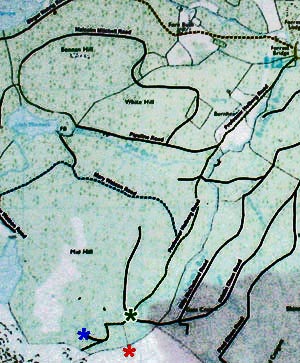
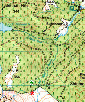
If we refer back to page 23 when I had to make the decision on which way to go from the vehicle turning point that I came up to from the stile. I made the wrong choice there because the Ordnance Survey map has been left behind by the changes to the forest roads at this point. The estate's map is changed each year it seems - they just fade quickly - and it reflects better the real situation on the ground. Even at that it seems that the road which led me to Loch Minnoch is not even on their maps yet either, and Brian reckons I may be the first person to have walked it!
He also reckons that the stile is actually further west that is shown on the OS map and the vehicle turning point is actually where I have put the blue asterisk on the estate map below - (remember that the road I went from there heading north east isn't actually on their map yet).
So referring back to the picture at the top of the page what I should have done was head east along that zigzag road (which you can see clearly both on their map and the picture) down past the wee tower (which is actually for culling deer and not a fire tower) and so into the trees. Where this road enters the trees I have marked with a green asterisk on both maps and it is from this point that the maps begin to agree with each other. Of course when the young trees in the foreground of the picture grow everything beyond the stile will be hidden by forest as seen from this viewpoint. But this is what it looked like on 18th March 2009.
For me personally it is reassuring that my navigation skills did not let me down on the day - it was more a lack of accurate information on the OS map - which is hardly surprising when the whole road layout here is in a state of flux.
Thanks Brian for putting me right. I can join the ranks of the sane again - maybe.
Page 01 -