|
Rhinns of Kells from
Craigencallie
|
|
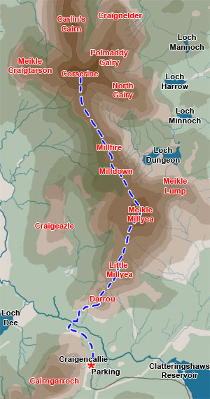
Map of a linear hill walking
route from Craigencallie onto the Rhinns of Kells going over Darrou,
Little Millyea, Meikle Millyea, Milldown, Millfire and Corserine.
|
|
Click on the left side
of the image to go back to the previous image and on the right side
of the images to go to the next image
|
|
| 01 You pick up the road into Craigencallie
just west of the dam at the southern end of Clatteringshaws
Reservoir. You drive along this narrow road until you come to a locked
gate across the road just past Craigencallie Outdoor Centre (NX504783).
There is a car park there
for several vehicles. From there you go over the gate and head along
the forest road in the direction of Loch Dee until after about 1km you
come to another forest road branching off to the right. As you turn into
this road you will see a quarry low on the side of the hill opposite you.
Make for the quarry, then head up through it and through the firebreak
on the hill leading from it and you are now beginning to climb Darrou.
All the pictures on these pages were taken on 21st February 2000 and mostly
by Sandy. There is a good profile picture of Darrou, Little Millyea and
Millyea in the second page of the Clatteringshaws
link given above. We took just under 5 hours going outward to Corserine and just over 3 to come back - there was the half hour for lunch and plenty of pictures taken on the way out. The views were great all day, even into the evening - it was 5.55pm before we were back at the car, which was cutting it a bit fine for light especially with a forest ride to find down to the quarry. |