or, on the right side of it to go to the next page.
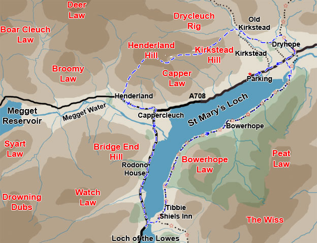
01 There is not a great deal of hill climbing involved in this route
but it is nevertheless an interesting walk with considerable historic
interest. We did the walk anti-clockwise.
We have to park in a lay-by beside the A708 (the Moffat to Selkirk road)
and walk NW along this road till we meet the Southern
Upland Way just beyond Dryhope. We visit Dryhope Tower and then head
west onto the hills, getting fine views over St Mary's Loch, Loch of the
Lowes and the Megget Reservoir, before descending to the Megget Water
at Henderland. We then head SE to Cappercleuch and from there follow the
A708 south to Tibbie
Shiels Inn where we pick up the Southern Upland Way and head back
along the southern shore of St Mary's Loch back to Dryhope and the car.
We took 6 hours 10 minutes to this walk but we had stopped for some lunch
at the Glen Cafe near Tibbie Shiels and were also into Tibbie Shiels for
a pint - a leisurely day. If you wanted a tougher day you could head up
onto The Wiss and over by Peat Law to Dryhope which might be quite interesting.
In October 2015 I recieved this email from Ettrick and Yarrow Community
Development Company. As I see that you have
a walk around St Mary's Loch on your website, you might be interested
in the attached leaflet. It describes a circular walk around the loch
that the Ettrick and Yarrow Community Development Company has recently
completed and is now promoting to encourage visitors to our valleys. It's
a shorter and lower level walk than the one on your website but, at about
seven miles of mainly level walking, is one that we hope will have wide
appeal. With the exception of a short stretch of verge walking it also
stays off the main road, which has always been the main problem with trying
to walk right round the loch. The walk is well signposted and waymarked,
and the leaflet is widely available from the local pubs, cafes, information
centres, b&b's, etc.
Here is a link to further
walks in the area from Ettrick and Yarrow Tourism Group.