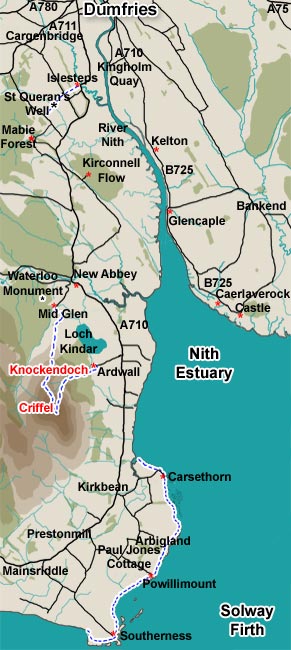
As you can see from the map the west bank of the River Nith runs much further south into the Solway Firth than the east bank does. Also for much of the length of the west bank access to the river bank is not easy. The more easily accessible coastal walking area starts at Carsethorn and extends to Southerness and beyond. Routes from Ardwall and Mid Glen onto Criffel have their own web galleries.
Here we will look at walking routes at St. Queran's Well, Mabie Forest, Kirconnell flow, and the coastal area from Carsethorn to Southerness.
The route at St Queran's well is a short but interesting linear walk from Islesteps.
Mabie Forest has a rich variety of official way-marked walks and demanding mountain bike routes.
There are really two walks at Kirconnell Flow, one a short pleasant walk through woodland and the other a more testing walk round the perimeter of the Flow itself. It is testing in so far as the surface of the path can be very muddy in places and slippery on the wet wood from which some of the path is constructed.
The area from Carsethorn to Southerness offers excellent coastal walking and good parking facilities at Carsethorn, Powillimount and Southerness. With pubs at both Carsethorn and Southerness, parking at Powillimount offers the possibility of walking to a pub and back. Mouseover the map to send the tide out.