| Queensberry,
Penbreck and Earncraig from Mitchellslacks |
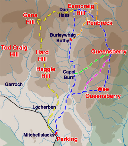
| Map
of a circular hill walk from Mitchellslacks over Wee Queensberry, Queensberry,
Penbreck and Earncraig and then back by Burleywhag Bothy |
| |
| Click on
the left side of the image below to go back to the previous page
or, on the right side of it to go to the next page. |
| |
01 As you can see in the map above there
are several routes you could take from Mitchellslacks into the Queensberry
hills. The one described in this web gallery is the blue route taken anti-clockwise.
You could cut out Wee Queensberry by taking the purple section to the top.
If you find the descent off Penbreck and ascent onto Earncraig too steep
for your liking you could take the orange section back to Burleywhag Bothy.
If you are feeling really energetic you could carry right on from Earncraig
onto Gana Hill on the yellow route. The green route is new to me. Signs
have recently been put by the track suggesting the green route to the top
of Queensberry. Of course you can use any combination of these routes that
you fancy or come down directly from Queensberry to Burleywhag.
In the past when we have done the full route over Gana Hill, Earncraig,
Penbreck and Queensberry we have usually gone clockwise because it is easy
to find the place to cross the Capel Burn not long after you leave Mitchellslacks. |
|
|
|
|