or, on the right side of it to go to the next page.
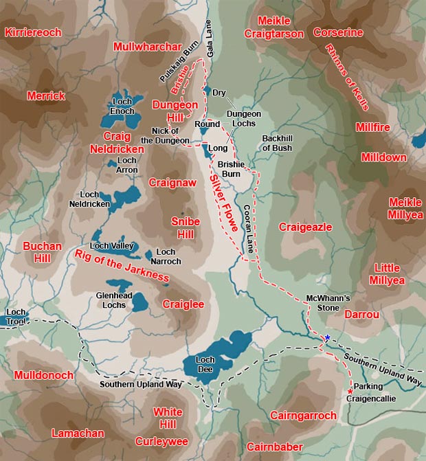
01 This walk (shown in red in the map above) starts from the carpark
beside Craigencallie House (OS Ref. NX503781) and involves quite a few
kilometers of walking on forest roads both on the outward and return journeys.
Sandy and I took a chance on sneaking our car along the forest road with
the intention of driving to Backhill
of Bush. You are not actually supposed to drive on these forest roads
but we absolutely hate walking on them and we have parked near Backhill
in the past with no problems. You just try to sneak in, have your day
on the hill, and sneak out with no fuss and no problem to anyone as though
you had never been there.
However, the forest road is very rough going for an ordinary car, and
you have to drive through gates that you might find locked on the way
back out at the end of the day. We got as far as the blue asterisk (in
the map above) near the quarry at Darrou and Sandy thought we should not
drive any further when we came to the gate there - in case we got locked
in for the night. So that is where we started from but you can avoid all
this mildly clandestine stuff by just parking at Craigencallie
- which can be accessed from the public road which leaves the A712 just
west of Clatteringshaws Reservoir.
The Silver
Flowe is such a magical place that you just have to put up with all
the dreary forest road to get there every once in a while.
Scottish
Natural Heritage website describes it as follows:
Silver Flow National Nature Reserve is a blanket bog of international
importance. This is reflected in its designation as part of the larger
Merrick Kells Biosphere reserve, which is the largest upland area in Galloway
unaffected by tree planting, and as a Ramsar site for the quality of its
peatlands and wetlands.