Hill walk routes to climb in SW Scotland
- also coastal paths and National Scenic Areas with maps, pictures and
other useful information based on extensive local knowledge
|
||||||||
The Dungeon Hills - Page Two
|
||||||||
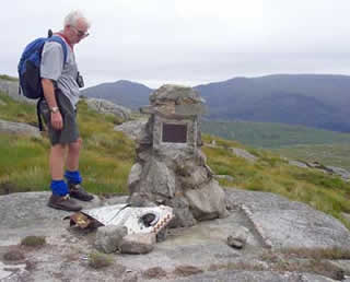
The picture on the right was taken by Sandy on a quite different day. That's me contemplating the bits of wreckage of an F111 which crashed here on 19th December 1979. You find bits of it as you walk along and there is always some there by the monument adding to the poinancy of the place. Somehow you really identify with the guys who died and kind of feel their presence all around - like it is for ever their place and you are their visitor. There is a sheer rock face straight behind where I am standing and presumably that is what they hit. Mouseover for a closeup of the plaque. |
![]() |
|||||||
I
suppose when they come upon the bodies of long dead climbers high up in
the Hymalayas there must be the same sort of feeling that these people have
become imprinted on that place for ever. To me there is a rightness about
it - not at all a bad place to be eternally at one with. Another thing to
contemplate is that Mark whom you see on most of the pictures on these pages
was, on the day the pictures were taken, just slightly older than the older
of the two pilots when they died. They would have looked much like him on
these hills. Also that same pilot if he were still alive would be around
5 years younger than I am in this photograph. That thought adds another
dimension to the Scots' phrases, "We're aw Jock Tamson's bairns"
and that, "Man tae man the world ower shall brithers be fur aw that".
You certainly think about these things when you come across such monuments
in the hills. They always engender feelings of mankind-wide compassion in
such personal terms - relating your own family circumstances to that of
the pilots. |
||||||||
![]() |
The picture on the left shows how rock-strewn the top of Craignaw is. The hill near the right edge is Mullwharchar - where we are heading. We will then descend to the loch - which is Loch Enoch and come down the Buchan Ridge back to Glentrool. This is quite a tough day's hike. The hill on the left edge of the picture is Merrick then Kirrieroch the low one is Tarfessock then the big one furthest in is Shalloch on Minnoch - all part of the range of the Awful Hand. | |||||||
![]() |
![]() |
![]() |
||||||
This is another shot from the rocky top of Craignaw looking north to Mulwharchar with Dungeon Hill in front of it. | 
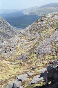
Moving on north from the top of Craignaw there is a short sharp descent to the top of the Nick of the Dungeon. |
Looking down the Nick of the Dungeon to the Dungeon Lochs and the Silver Flow with the Rhinns of Kells beyond. | ||||||
![]() |
![]() |
|||||||
This area of flat rock is known as the "Deil's bowlin green" (meaning something like the "devil's bowling green" in English). The great rock face on the right is Dungeon Hill and Mullwharchar lies behind. | Tiny lochins like this are quite common in these hills. Merrick and Kirriereoch are in the background. | |||||||
|
||||||||
![]() |
![]() |
![]() |
![]() |
![]() |
![]() |
![]() |
![]() |