The map on the left shows the Nith Estuary at high tide - mouseover to see it at low tide. The biggest tide of the year (2007) was 9.4 mts on 20th and 21st March. You can see that the estuary changes dramatically with the coming and going of the tides. The river is tidal up to the Caul in the centre of Dumfries. You can also see how large the areas of mudflat are. There are signs along the river at various points warning of "FAST FLOWING TIDES AND QUICKSANDS" and you shouldn't venture out onto them unless you know what you are doing. Where the riverlets run through the mudflats is particulary to be watched I have been up to the knees in the sucking mud there and it's not funny!
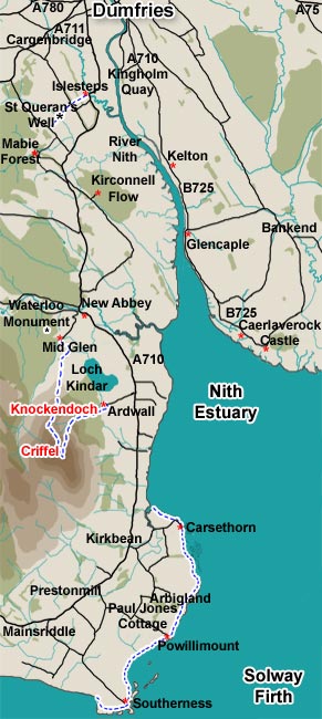
This map shows the whole Nith Estuary down river from Dumfries town. The Nith National Scenic Area starts half way between Kelton and Kingholm Quay and takes in the river and estuary south of that as far as Arbigland. It also stretches east to take in the Caerlaverock Wildfowl Trust area which is not shown on this map. I have walked across the merse from the Wildfowl Trust to Caerlaverock Castle but it is trackless and messy going.
The red asterisks show parking places which are useful for walkers. The roads are narrow and parking on the road just causes hassle for others. So it is better to park off the road if you are going to leave your car for any length of time. Some walking routes are shown on the west bank.