Hill walk
routes to climb in SW Scotland - also coastal paths and National Scenic
Areas with maps, pictures and other useful information based on extensive
local knowledge
Around Mulberry Harbour Remains
Garlieston
Map
of a coastal walk among Mulberry Harbour remains around Garlieston, Wigtownshire
Click on
the left side of the image below to go back to the previous page
or, on the right side of it to go to the next page.
or, on the right side of it to go to the next page.
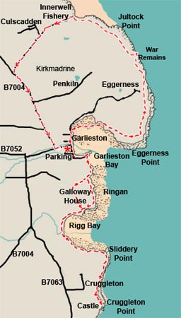
We arrived in Garlieston via the A75 which we left at the Newton Stewart turn-off - from where we took the A714 down past Wigtown and Kirkinner (which is on the A746). Just south of Kirkinner you fork left onto the B7004 for Garlieston.
The route shown here took us a quite strenuous seven hours but obviously you can choose whatever bits of the route you fancy doing. We headed north out of Garlieston, then east to Eggerness Point and up past the war remains to Innerwell Fishery from where we walked back by the tarred road to Garlieston (which is no great fun). You might choose to go only as far as the war remains or even Innerwell Fishery and then come back by the way-marked path you went out on, have your lunch in Garlieston and then do the southern leg of the route to Cruggleton Castle in the afternoon. There is also plenty of easy walking around the gardens of Galloway House.