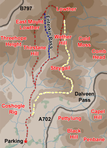
01 The map above shows
what is essentially a single walk, over Steygail, Wether Hill, Lowther
Hill, East Mount Lowther, and Thirstane, with three possible shorter variations.
The red route taken in a clockwise direction is the one shown in this
web gallery and is one of the variants of that main walk.
The yellow and blue routes which you see in the map above have their own
web gallery called Steygail
and Enterkin Pass. A hillwalker would see the variants as possible
escape routes from the main walk.
The main walk here is the longest and toughest. On it you go up by Steygail,
Wether Hill, Lowther, East Mount Lowther and Thirstane - thereby combining
the highest sections of the red route with the yellow route. If you want
to shorten that you can come off on the saddle between Steygail and Wether
Hill (shown in green) or you could go up over Lowther Hill and down the
Enterkin Pass (in blue). You can of course do any variant of these routes
clockwise or anti-clockwise.
In this particular web gallery we went clockwise onto Thirstane first,
over East Mount Lowther to Lowther and then descended off Wether Hill
exactly as in the red route.
As soon as you start away from the parking place on all of the routes
shown here you are on the historic old bridle route from Dumfries to Edinburgh
or Glasgow which at this point travels up the valley of the Enterkin Burn
and onto the Enterkin Pass and up to the saddle between East Mount Lowther
and Lowther Hill. The old bridle route continued on it's merry way north
from there.