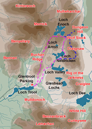
Craignaw and the Dungeon Hills
Map
of a circular hill walk in Galloway Forest Park from Bruce's Stone by
Loch Trool up the Gairland Burn past Loch Valley and Loch Neldricken to
Craignaw and Dungeon Hill, then back by the Wolf Slock, Criagneldricken
and the Buchan Ridge
Click on
the left side of the image below to go back to the previous page
or, on the right side of it to go to the next page.
or, on the right side of it to go to the next page.
The route in this web gallery combining the purple and blue routes was done on 9th August 2007. The 2006 Wolf Slock walk was done on a steamingly hot day (for Scotland) and the visibility was not quite so good as in the 2007 Craignaw day. It is interesting to compare similar scenes at a similar time of the year in similar sort of weather (though not so hot in 2007) and see how the experience of doing the walk can differ so much as a result of conditions on the day and of the weather leading up to that day - 2006 was done in a long spell of hot dry weather and 2007 after the wettest summer weather on record. Each day has it's own subtly distinctive feeling in the hills and it is those feelings which draw people into the hills again and again. Of course your own mood on the day is a big factor too - but the camera cannot pick that up unless in the choosing of the images taken.