or, on the right side of it to go to the next page.
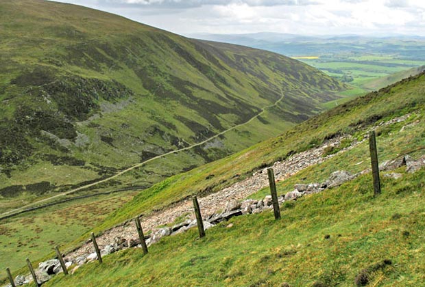
24 From Well Hill we descend
steeply down to the vehicle track which goes from Durisdeer to Troloss
and which you see in this picture above. We will return to Durisdeer down
the ridge that desends from left to right across this picture - Durisdeer
Rig.
It is at this point between Well Hill and Durisdeer Hill that this track
and the old Roman road from the Roman fortlet near Durisdeer merge into
one due to the narrowness of the saddle. This route that we are looking
at through these hills is very ancient and is known as the Well Path.
Below are texts about the Well Path taken from a paper written by Harry
RG Inglis in the Proceedings of the Society of Antiquaries of Scotland
and called "Ancient
Border Highways" (10th March 1924). The link here will
take you to a page called "Resources on Old Scottish Roads"
which in turn has a link to the Inglis article.
Here is a range of hills nearly all 1500 feet
high, and occasionally rising to 2000 feet, stretching across Scotland.
There are only a small number of passes, and all ordinary traffic from
Dumfriesshire must pass through one or other: Wheelrig, 1350 feet; Note
of the Gate,
1238 feet; Limekilnedge, 1160 feet; Mosspaul, 890 feet; Eskdalemuir, 1100
feet; Birkhill, 1120 feet; Erickstane, 1330 feet; Beattock, 1028 feet;
Well Path, 1290 feet; Enterkin, 1890 feet; Leadhills, 1530 feet. Ofthese,
Erickstane, Mosspaul, and the Well Path are the only ones that give a
fairly direct connection between northern and southern towns. Other passes
are to be found without doubt, but none makes such a fairly direct and
unmistakable highway as these three in which the traveller can go without
fear of losing himself among the hills, and these passes must, from time
immemorial, have been the highways between the north and the south.
....the very, ancient highway that led past Biggar and the Well Path to
Durisdeer, Penpont, and on through St John's Town of Dairy to Minigaff
and Whithorn....
[Well Path] One of the great highways of olden times
was the direct road from Edinburgh to Whithorn in Galloway, and it is
remarkable how much of it is preserved to-day as a hard-beaten track alongside
or parallel to the present road.