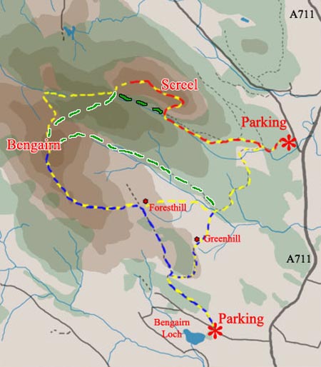
01 Several routes are shown here. The red and yellow route is one of the most popular routes in South West Scotland. To get here take the A711 through Dalbeattie and Palnackie until it meets the road coming down from Threave Gardens through Gelston to meet the A711.
The steep rocky east face of Screel can't be missed on your right as you approach this road end - see picture 02. Parking is on your left about 100 yards up the side road to Gelston (O.S. Ref NX800547).
Most people simply go up the route shown here in red and yellow and come back by the same route. Others descend from the steep west end of the Screel ridge and come back along the forest path (shown in green and black).
You can continue onto Bengairn by the yellow route though few folk do this because the first part of this route is awkward - you either follow the line of a dyke through the trees along a very wet path or you take the slightly higher route through almost trackless heather - the latter route is shown in these pictures.
Once on Bengairn you can keep on the yellow route past the ruined house at Foresthill, make your way down to and across the Troudale Burn, then up through the wood and onto the forest track which will lead you back to the red route again.
You can also park near Bengairn Loch (O.S. Ref NX 791523) and take the blue route onto Bengairn and back, or you can carry on to Screel and do the circle in the opposite direction from that described above except that you come back by the ruined house at Greenhill rather than Foresthill. It is easy to get confused by the two ruined houses which look fairly similar. You can see a couple of pictures taken on this route on pages 29 and 30.
The green and white route over the shoulder of Mid Hill is one that I started using in 2012. Trees were felled between Screel and Bengairn around 2010/2011 and so a route opened up through this felled area if you follow the tracks created by the vehicles which brought out the felled wood. It is as always rough going getting through felled areas but the vehicle tracks make this somewhat easier and for me this is preferable to the wet section shown in yellow on the map above which we had previously used to get you from Screel to Bengairn.
Also, in 2012 I discovered the route shown in green and white in the map above which brings you off Bengairn and then down a forest track by Troudale Gill back to the parking area. This route has obviously been used for a long time by others but I had never followed the forest track up far enough to find the gate at the end of the track and the pleasant route up onto Bengairn thereafter. See Page 30 for pictures of this route. This is a really good straightforward way of getting onto Bengairn.