Hill walk routes to climb in SW Scotland - also coastal paths and National Scenic Areas with maps, pictures and other useful information based on extensive local knowledge
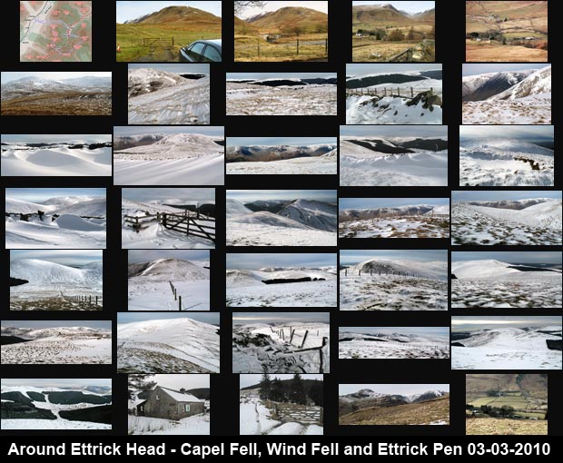
Around Ettrick Head - Capel Fell, Wind Fell and Ettrick Pen in Winter
A circular walking route in the Ettrick hills around Ettrick Head - over Fauldside Hill, White Shank, Capel Fell, Wind Fell, Hopetoun Craig and Ettrick Pen - from Capplegill on Moffat Water.

Site Homepage - West Borders Home - Large Map of West Border Hills
List of West Border Web Pages - Moffat Hills Introduction

Click on any picture to go to a larger version of it
Thumbnails of a winter walk in the Ettrick hills. Map of a walking route around Ettrick Head - over Fauldside Hill, White Shank, Capel Fell, Wind Fell, Hopetoun Craig and Ettrick Pen Views around the parking area at Capplegill. Views from the track which goes to Bodesbeck farm from the A708. Finding the route onto Fauldside Hill from Bodesbeck farm. Views of Moffatdale from Fauldside Hill. Views of Bodesbeck Law, Fauldside Hill, White Shank, Smidhope Hill and Capel Fell Views of Bodesbeck Law and the Moffat Hills from Fauldside Hill. Views from the top of Fauldside Hill. Views from the top of Fauldside Hill - the County Boundary, Ettrick Pen and White Shank. Views from the top of Fauldside Hill - Bodesbeck Law and the Moffat Hills. Wind-blown snow sculptures on White Shank. Bodesbeck Law from the top of White Shank. Views from White Shank in the Ettrick Hills. View of the valley of Ettrick Water from near the top of Smidhope Hill. Views from the top of Smidhope Hill. Views from the top of Smidhope Hill - Loch Fell, Ettrick Pen and snow sculptures. Views along the route from Smidhope Hill to Capel Fell. Views from the top of Capel Fell - Croft Head and Broken Back. Views from the top of Capel Fell - the Moffat Hills, Ettrick Pen, Wind Fell and Loch Fell. Views from the top of Capel Fell - Moffat Hills and Ettrick Water valley. Pictures of the route between Capel Fell and Wind Fell. Views from Wind Fell - Capel Fell, Croft Head and Loch Fell. Views from Wind Fell over the White Shank/Smidhope/Capel Fell ridge to the Moffat Hills beyond. Views from the top of Wind Fell - Loch Fell, Bodesbeck Law and the Moffat Hills. Views from the top of Wind Fell showing the route to Ettrick Pen. Views from the top of Hopetoun Craig towards the Moffat Hills. Views on the route from the top of Hopetoun Craig to Ettrick Pen. Views from the cairn on the top of Ettrick Pen - to Wind Fell and Capel Fell and to the Moffat Hills. Leaving the top of Ettrick Pen with views towards the Moffat Hills. Views taken while descending from Ettrick Pen - towards Hopetoun Craig and the Solway Firth. Approaching Over Phawhope bothy from Ettrick Pen. Views of Over Phawhope bothy - exterior and interior. Pictures of the track from Potburn to Bodesbeck. Views of the Moffat Hills while descending towards Bodesbeck farm. Views of Moffatdale from the path down to Bodesbeck and of the Ettrick Hills from the car park at Capplegill.
Site Homepage - Border Home - Large Map of Borders - List of Borders Pages
Moffat Hills Introduction
- Moffat Hills Introduction